
Transitioning to become a “Smart City” has become an all too common goal for cities with populations ranging from a whopping 10 million+ to those with only a mere 10,000. One of the ways cities have attempted to fulfill their “Smart City” aspirations has been through the implementation of parking technology; however, with so many solutions available that focus on various parts of the parking experience, cities have become lost in this sea of parking insanity. These technologies range from on-street to off-street, payments to availability, restrictions to reservations and beyond.
A more common trend amongst cities looking to have a parking solution has been to implement mobile parking payments. In many ways, this has been successful; however, cities currently utilizing this technology continue to miss one of the most fundamental parts of this system unbeknownst to them resulting in lost revenue and ineffective enforcement.
When a city implements mobile parking payments via a 3rd party partner, the technology relies heavily on accurate on-street parking restriction information. This includes the physical locations of parking areas, the zone number of paid locations and the “rules” for payment relating to the corresponding zone. Without these restrictions being digitized accurately and properly, 3rd party mobile payment providers improperly charge those who use the service while cities lose revenue, enforcement becomes difficult and the user experience is negative.
At Parknav, our goal is to provide the complete “in the car to out of the car” experience while ensuring our solutions are accurate and effective. While we are known for real-time on-street and off-street parking availability and turn-by-turn voice guided parking navigation, we also provide detailed static on-street parking restrictions (ie. where it is legal and illegal to park / where it is paid, etc) and off-street parking facility locations in all of the 1000 cities we operate in. We do not do mobile parking payments; however, many mobile parking payment providers rely on our restriction mapping service to better serve their customers (cities).
When Parknav was requested by one of our mobile parking payment partners to begin our real-time on-street parking availability service in the city of Bonn, Germany, we were first provided a digitized copy of the payment zones via the “Smart Parking” program in Germany. These digitized copies are typically shared with all mobile payment providers and taken at “face value” without ground truth verification. While this digitized copy appeared comprehensive, we at Parknav always verify all data provided to us through ground truth assessments and actions. The results were quite eye opening.
Below is just an example of a street we tested.
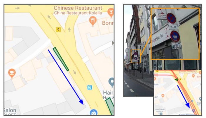
In this example, we tested a street called Belderberg. The image on the left was generated from the file provided to us by the “Smart Parking” program with payment parking areas highlighted in green. In the end, we determined the paid area highlighted in green did not physically exist and actually had zero legal parking spaces. It quickly became clear to us that a significant portion of these restrictions were incorrect. Therefore, we re-mapped the entire city and provided our mobile parking payment partner with the most accurate up-to-date parking restriction information. Unfortunately, as of February 24th, 2020, all of the other mobile parking payment providers operating in Bonn still show this street incorrectly with a paid area.
While we focused this blog entry on an example in the city of Bonn, this situation is not an abnormality for cities around the world. In fact, it is more common than not. The cost of continuously mapping and re-mapping a city has traditionally been expensive, and most cities do not have the resources nor believe they are able to afford continuous updates. Parknav is an expert in mapping cities and can prevent these types of situations at a price that would surprise most. In doing so, we are able to maximize the impact of mobile parking payments for both providers and “Smart Cities” alike.
When mapping a city’s parking restriction information, Parknav is able to identify and digitize:
- Illegal parking areas (locations, days, hours of day)
- Free parking areas (locations, days, hours of day)
- Paid parking areas (locations, days, hours of day, zones, pricing)
- Residential permit parking areas (locations, permit ID, days, hours of day, zones, pricing)
- EV parking/charging areas (locations, days, hours of day, pricing)
- Disabled parking areas (locations, days, hours of day)
- Loading zones (locations, days, hours of day)
- …and more
Want to learn more about how we can do this for you? Contact us at contact@parknav.com.
Written by Jeremy Leval
Want to learn more?
Let’s talk parking…and much more !

We’d love to answer all your questions
Let us know how we can help solve all of your parking needs, parking restrictions, traffic control, smart city information….or just say hi !

